Highlights

  • Makalu Trekking
  • Sherpini cool 
  • Everest Region
  • Rolwaling area 
  • High passes trekking
  • Adventure part 
  • climbing route 

About Great Himalaya Trail (35 days) 2nd step

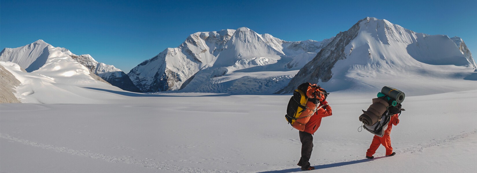
This is the 2nd shift in the Great Himalayan Trail. The trail goes through Makalu, Everest and Rolwaling which is an upper region of Everest. This shift is a 34-day trek in the Everest region. The Everest region is the most trekked region of Nepal. Trekkers all over the world want to trek through this trail just because mighty Everest; the highest mountain in the world lies here. In this trial, you will get to rejoice in all the glory of the Mt Everest region. For example, you will get to experience the famous Sherpa hospitality, see the glorious Himalayas of Nepal and taste the Sherpa culture and tradition. 

This trail may be one of the longest but at the same time, it is one of the best trekking trails. Not you will get to explore all the delights of the Everest region, but you will be open to the beauty of the mountain. The highest altitude you will experience during this trek is while crossing Sherpini cool west pass at an altitude of 6143m. During the trek, the glorious views of mountains like Nuptse, Lhotse, Ama Dablam, Cho Oyu, Dorje Lakpa, Makalu, Everest, Baruntse, and many more are visible. Likewise, you will cross many passes like Cho la pass, Aphu Labsta pass, and so on. Another beautiful aspect of this shift is you will get to explore the beautiful Rolwaling region situated between the Everest and Langtang region. 

Trekking in Nepal has very interesting aspects because you are continuously surprised. Sometimes you can see plain lands amidst the stunning Himalayas, deep valleys, unique landscapes, and so on. One moment you will walk through the lush rhododendron jungle and next you will find yourself in between deep valleys with amazing Himalayas landscapes. As this is a camping trek in Nepal, you will have a different experience than tea house trekking in Nepal. Himalayan Ecological Trekking operates this 2nd shift Makalu Everest Rolwaling Trek with experience and an amazing crew to give you the raw taste of trekking in the Himalayas of Nepal.
 

Itinerary

Expand all +Collapse all -

Day 1: Pick up from airport transfer to the Hotel

Warmly welcome at Tribhuban international airport. Our representative will get you and transfer you to the hotel. He will explain to you shortly about your program. After this, free day up to your timetable leisure day overnight hotel.    

  • Accommodation3 Star category Hotel
  • Mealsup to your choose
  • PlaceKathmandu
  • Max. Altitude1375 m

Today is the full day sightseeing in UNESCO world sites in Kathmandu valley Pashupatinath, Baudhanath stupa, Monkey Temple & Kathmandu durbar square with culture society. You will have your own guide & private car or bus. We have a good experience guide about the city. Himalayan Ecological Trekking attempt to provide the best service happiness in life.

  • Accommodation3 Star category Hotel
  • Mealsup to your choose
  • PlaceKathmandu
  • Max. Altitude1375 m

We journey to Tribhuvan International Airport for our flight to Tumlingtar, which is a brief 35-minute flight away. Upon our arrival in Tumlingtar, we will arrange for a jeep to transport us to Num. The route to Num is a challenging off-road journey, spanning approximately 4 to 5 hours. As we navigate this rugged terrain, we'll be treated to breathtaking landscapes, including views of snow-capped mountains, charming local settlements, and serene forests.

In the evening, we'll stay lodged at a guest house where we can savor local cuisine and take some well-deserved rest

  • AccommodationTent camp
  • Mealsown cook making
  • PlaceNum
  • Max. Altitude1572 m

 Today marks the beginning of our trekking adventure. Our journey starts with a descent of approximately 900 meters until we reach the Arun River. After crossing a suspension bridge, we'll face a challenging ascent of the same 900 meters to reach Seduwa. Along the way, we'll take a break for lunch. The trek will lead us through picturesque traditional-style houses, showcasing the rich cultural heritage of the area.

Seduwa boasts a conservation office where our permits will be checked. This settlement is home to the Rai and Gurung ethnic groups, offering a glimpse into their unique way of life. The total trekking duration is estimated to be around 4 to 5 hours. Our overnight accommodation will be in tented camps, allowing us to fully immerse ourselves in the natural beauty of the surroundings.

  • AccommodationTent camp
  • Mealsown cook making
  • PlaceSeduwa
  • Max. Altitude1510 m

After beginning our day at the campsite take-off, we embarked on a short uphill climb before turning towards the northwest. The trail was in excellent condition, making our journey quite pleasant. Along the way, we passed through several small settlements.
Approximately two and a half hours into our walk, we reached Chyaksadanda. This place is equipped with a store catering to both villagers and travelers, where we can purchase any supplies we may need. Chyaksadanda is the last opportunity to buy essentials for our trek, so it's a good place to stock up. It offers a nice spot to relax, enjoy some leisure time, and even have lunch.

From Chyaksadanda, it will take us another two and a half hours to reach Tashigaon. Tashigaon is a village primarily inhabited by Sherpa people and is known for its fertile agricultural land. The elevation of Tashigaon is 2080 meters.

  • AccommodationTent camp
  • Mealsown cook making
  • PlaceTasi gaun
  • Max. Altitude2100 m

Starting from the Tashigaon hotel, you'll cross over a ridge and make your way through the forest until you reach a stream. The path will level out briefly on the following ridge before ascending towards a shepherd's hut situated atop another ridge, known as Chipla. From this point, the trail becomes even steeper, leading you up past streams and a massive overhanging rock before reaching a small Kharka (grazing meadow) within the forest. The journey continues over rocky terrain and tree roots until you reach Unshisha, a small and often damp meadow situated at an altitude of 3180 meters.

The final leg of your trek to Khongma is a demanding climb through the forest, following the ridge that separates the Isuwa Khola and Kasuwa Khola. After roughly an hour and a half of hiking, you'll come across a signpost marking the national park campsite and a hotel. It's advisable to spend the night at the hotel at this point for your convenience and comfort.

  • AccommodationTent camp
  • Mealsown cook making
  • Placekhongma Dada
  • Max. Altitude3500 m

Starting from Khongma, follow a steep series of switchbacks along the ridge, leading you to a stone Chorten. From here, you'll be treated to breathtaking vistas of Chhamlang Peak 6 (6739m) and Peak 7 (6105m). As you ascend, you'll encounter rhododendron bushes, and continue on a staircase that traverses several deceptive ridges, ultimately leading to a modest pass known as Ghyngro La.

Descend alongside the enigmatic Kalo Pokhari, a serene lake resting at 3840m. Then, brace yourself for a steep ascent to Shipton-La at 4220m. Once you descend on the other side, you'll come across another tranquil lake. The trail skirts this lake and ascends to a clear depression in the hills on the opposite side, which is known as Keke-la (4150m). In the final, rigorous climb for the day, you'll approach the pass. The path then leads you into a picturesque valley adorned with rhododendrons, creating a vibrant floral carpet during springtime. Approximately one and a half hours of walking from this point, you'll find either a tea house or a suitable camping spot in the meadow just below the pass, known as Mumbuk (3560m).

  • AccommodationTent camp
  • Mealsown cook making
  • PlaceMumbuk
  • Max. Altitude3540 m

Starting from Mumbuk, the trail descends a slope covered in scree, leading you into the sweeping and gracefully curving Barun valley. This valley serves as a natural pathway toward your ultimate destination. As you make your way downhill, follow the streambed and then head west along the southern edge of the valley. Be mindful of your footing as you navigate around tree roots, clamber over landslide areas, squeeze through gaps between boulders, and leap across small streams it will come small tea shop where we can have lunch.

As you proceed beyond the landslide areas, the valley gradually opens up, and the forest begins to yield to expansive alpine meadows. From here, you can enjoy splendid vistas of peak 7. After about half an hour's walk, the trail leads you to a point where you can safely cross the Barun River. At this juncture, you'll find an excellent spot for camping, and there's also a tea house nearby that serves delicious food in Yangle Kharka.

  • AccommodationTent camp
  • Mealsown cook making
  • PlaceYangla kharka
  • Max. Altitude3557 m

Today, we are embarking on a 450-meter ascent to Makalu Base Camp. As we begin our journey, we will encounter two tea shops where we can savor a simple meal and take a well-deserved break. During our first stop, we will be treated to the sight of a picturesque waterfall cascading from a cliff.

Continuing our trek, we will navigate a rocky path along the right side of the Barun River for about one and a half hours. On the left, we'll have the opportunity to gaze upon a stunning Glacier Lake, offering breathtaking views of the mountains and an immense glacier. As we relish these scenic vistas, we will proceed with our climb, eventually arriving at a second tea shop, where we can once again rest and rejuvenate.

From this point, it's just half an hour until we reach the Makalu Base Camp, where we'll be greeted with a close-up view of Mt. Makalu, standing proudly before us. Makalu Base Camp provides three accommodation huts. You can stay in one of the huts or choose to set up your own camping spot. It's a serene location where you can unwind and appreciate the evening in the company of nature's beauty.

  • AccommodationTent camp
  • Mealsown cook making
  • PlaceMakalu base camp
  • Max. Altitude4870 m
Today, we need to acclimate ourselves early in the morning so that we can embark on a three-hour hike to reach a scenic viewpoint. Upon reaching the summit, we will be treated to breathtaking panoramic views of the mountains. Once at the top, we should take at least a 20-minute break to allow our bodies to adjust to the higher altitude. Afterward, we can return to our campsite and relax, preparing for the next exciting trekking adventure.
  • AccommodationTent camp
  • Mealsown cook making
  • PlaceMakalu base camp
  • Max. Altitude4870 m

Today's hike is reminiscent of the Morin part, featuring rugged and rocky terrain. We'll be ascending to approximately 350 meters above Makalu Base Camp, reaching Swiss Base Camp. The trail takes us around Mount Makalu, and while the conditions have been favorable up to this point, from today onward, we'll encounter a predominantly dry and glacier-covered path, punctuated by boulders. This portion of the journey is relatively easier compared to what lies ahead.

There won't be any designated lunch stops along the way, so we'll need to bring our own packed lunches and ensure we have an ample supply of water. Our estimated walking time for the day is approximately 4 and a half hours.

Once we set up camp, we'll be treated to spectacular views of Nupche and other surrounding mountains, providing the perfect opportunity to prepare for the adventures of the following day. In the evening, we can look forward to a satisfying hot dinner.

  • AccommodationTent camp
  • Mealsown cook making
  • PlaceSwiss base camp
  • Max. Altitude5150 m

Today, we are en route to the Sherpani Col base camp at an altitude of 5690 meters. Our ascent will cover a challenging 540 meters, characterized by a treacherous path strewn with large boulders and rocky terrain. The landscape is devoid of vegetation, dominated by a barren moraine and ancient glacial expanse. We need to ensure that we secure an ample water supply in the morning as sourcing it during the trek may prove to be a formidable task.

As we navigate our way around the mountain, it's imperative that we exercise caution while traversing the precarious terrain of these substantial boulders. Finding your rhythm and the best path is key to our safety and progress. Our camp for the day will be set up in a vast, flat area facing a colossal glacier. The setting will undoubtedly be cold, but it offers a unique opportunity to contemplate life and nature.

Tomorrow promises to be a significant day in our trek, so we should aim to have dinner early and retire to bed as soon as possible to prepare for the challenges ahead.

  • AccommodationTent camp
  • Mealsown cook making
  • PlaceSherpini col base camp
  • Max. Altitude5688 m

Today is a significant day as we are about to traverse two challenging passes: Sherpani Col and West Col. This journey is expected to take us around 9 to 10 hours before reaching our campsite. It's crucial to be well-prepared from the outset, as the morning temperatures are quite cold, ranging from -10 to 15 degrees Celsius.

Our day's adventure begins with navigating through a rocky terrain laden with large boulders. Subsequently, our climbing team will assist us in securing safety ropes as we transition to icy terrain. When tackling Sherpani Col, we'll encounter a spacious, flat expanse, which leads us towards the West Col. However, we must proceed with caution, as there is a risk of encountering crevasses.

Descending from the West Col presents its own set of challenges, with a tricky and precarious path to navigate. Fortunately, the end of our journey will reward us with a stunning campsite in a picturesque area.

  • AccommodationTent camp
  • Mealsown cook making
  • PlaceBarunche base camp
  • Max. Altitude5700 m

Today is a more manageable day compared to yesterday, with a walking distance of approximately 4 hours, similar to our rest time. We're feeling much more at ease today, in part because yesterday was one of the more challenging days of our trek. We are still making our way through the mountainous terrain. Along our route, we'll come across a tea shop, which is set up seasonally for trekkers and climbers heading to Mt. Barunche. This promises to be a comfortable spot where we can set up camp, and if we're fortunate, we might even find some food available, depending on the generosity of the local people. These locals, who travel from the Khare area or Mera Peak vicinity, engage in seasonal businesses to cater to the needs of trekkers like us.

As we continue, we'll be treated to intermittent views of panoramic mountains and the stunning Ice Lake. Once we reach our campsite, we'll be able to revel in the beauty of nature, creating a haven-like experience in this scenic environment.

  • AccommodationTent camp
  • Mealsown cook making
  • PlaceHungku
  • Max. Altitude5500 m

Today promises to be a relatively easy day, despite having to traverse rocky terrain. The well-defined footprints on the path will make it straightforward to navigate. We anticipate spending about 5 to 6 hours walking within the mountain valley. Our campsite is set in a picturesque location, complete with Ice Lake, providing a perfect opportunity to immerse ourselves in the beauty of nature and enjoy some much-needed relaxation. If you still have some energy left, you can explore the surroundings, but it's wise to conserve your energy for the challenging and potentially perilous pass we'll face tomorrow. In the evening, we'll savor a delicious dinner and rest well for the adventures that lie ahead.

  • AccommodationTent camp
  • Mealsown cook making
  • PlaceAmphu labsta base camp
  • Max. Altitude5200 m

Today marks the final day of our challenging journey through the treacherous Amphu Pabcha Pass. This pass poses significant dangers, and it's imperative that we carry climbing equipment at the top of our backpacks to ensure our safety. We'll be ascending nearly 750 meters to reach the summit, encountering large boulders and rocky terrain along the way. Beyond the rocky section, we'll face a massive expanse of ice that we'll need to traverse using our climbing gear.

Once we reach the summit, the most perilous part of our expedition awaits as we must descend a steep, rocky cliff while securely belaying ourselves. The reward for our efforts will be the breathtaking Imja Valley, where we'll be treated to awe-inspiring 360-degree panoramic views of the mountains, including the majestic Mt. Everest.

Following the challenging climbing portion, the path will become easier, and we'll have the opportunity to admire the serene Imja Lake. Our campsite today is in a picturesque area, providing ample time to rest and contemplate the beauty of nature.

  • AccommodationTent camp
  • Mealsown cook making
  • PlaceImja valley camp
  • Max. Altitude5100 m

 Today is a more leisurely day as we make our way down to the Chhukum valley. We'll have the opportunity to stay at a comfortable hotel. The walk today will take us around 3 to 4 hours, allowing us to relax and fully immerse ourselves in the natural beauty of the Khumbu region. Along the way, we may encounter yaks, wild sheep, and Tibetan chickens, all while enjoying stunning mountain views. In the afternoon, we can unwind and savor our time after lunch.

  • AccommodationTent camp
  • Mealsown cook making
  • PlaceChhukum
  • Max. Altitude4730 m
  • AccommodationTent camp
  • Mealsown cook making
  • PlaceChhukum
  • Max. Altitude4730 m
  • AccommodationTent camp
  • Mealsown cook making
  • PlaceLabuche
  • Max. Altitude4910 m
  • AccommodationTent camp
  • Mealsown cook making
  • PlaceGorakhchhep
  • Max. Altitude5162 m
  • AccommodationTent camp
  • Mealsown cook making
  • PlaceDgongla
  • Max. Altitude4820 m
  • AccommodationTent camp
  • Mealsown cook making
  • PlaceThannak
  • Max. Altitude(4700m) m
  • AccommodationTent camp
  • Mealsown cook making
  • PlaceGokyo
  • Max. Altitude4750 m
  • AccommodationTent camp
  • Mealsown cook making
  • PlaceGokyo
  • Max. Altitude4750 m
  • AccommodationTent camp
  • Mealsown cook making
  • PlaceLumden
  • Max. Altitude4328 m
  • AccommodationTent camp
  • Mealsown cook making
  • PlaceThame
  • Max. Altitude3820 m
  • AccommodationTent camp
  • Mealsown cook making
  • PlaceParchemuche Tsho
  • Max. Altitude4780 m
  • AccommodationTent camp
  • Mealsown cook making
  • PlaceTashi Lapcha Base Camp
  • Max. Altitude5665 m
  • AccommodationTent camp
  • Mealsown cook making
  • PlaceGlacier Camp
  • Max. Altitude4735 m
  • AccommodationTent camp
  • Mealsown cook making
  • PlaceKabug
  • Max. Altitude4820 m
  • AccommodationTent camp
  • Mealsown cook making
  • PlaceBeding
  • Max. Altitude3740 m
  • AccommodationTent camp
  • Mealsown cook making
  • PlaceSimigoun
  • Max. Altitude2036 m
  • Accommodation3 Star category hotel
  • Mealsfarewell dinner
  • PlaceKathmandu
  • Max. Altitude1375 m

    What's Included

    •  Airport pick up and drop all with tour planning
    • 3-star category hotel with BB plan in the city
    • Flight as per itinerary
    • All transportation as per itinerary
    • Insurance and Equipment Nepali crew
    • Government license holder Trekking Guide and Porter (2 Trekker = I porter for Camping Necessary)
    • City Tour Guide with entrance fees and private vehicle
    • Medical Kit ( first add box)
    • All government and local taxes
    • Farewell Teahouse or homestay accommodation during the trek
    • During the trek all meals:- Breakfast, Lunch, and dinner
    • Climbing Equipment for group
    • All Government paperwork with National park fees
    • Company Duffel bag
    • Domestic dinner tradition Nepali restaurant with culture program
    • Sat Phone set
    • Nepali visa fee
    • International Flight
    • Personal expenses (like-: Battery charge, Chocolate candy, P.T, Wi-Fi more)
    • Rescue insurance
    • City meals ( Lunch Dinner) and extra night due to early arrival trekking, overstay compare to plan any reason.
    • Personal Climbing Equipment
    • Any bottle of drink and all kind of alcohol
    • Money wire charge
    • Tips for Guide, porter, and driver ( all crew during the trek with driver)