Highlights


• Snow-caped mountains
•    Stunning glacier
•    Beautiful forest
•    Rhododendron woods
•    Beautiful solitude
•    Untouched captivating trekking trails
•    Off-the-beaten-trekking region
•    Pristine and intact from the western culture
•    Eye-catching natural beauty
•    Isolated trail
•    Home of numerous flora and fauna
•    Floral exploration on your trail
•    Breathtaking view of eight thousand’ mountains: Kanchenjunga (8586m), Mt Everest (8848m), Lhotse (8516m), Makalu (8201)

About Kanchenjunga Base Camp Trek - 18 days

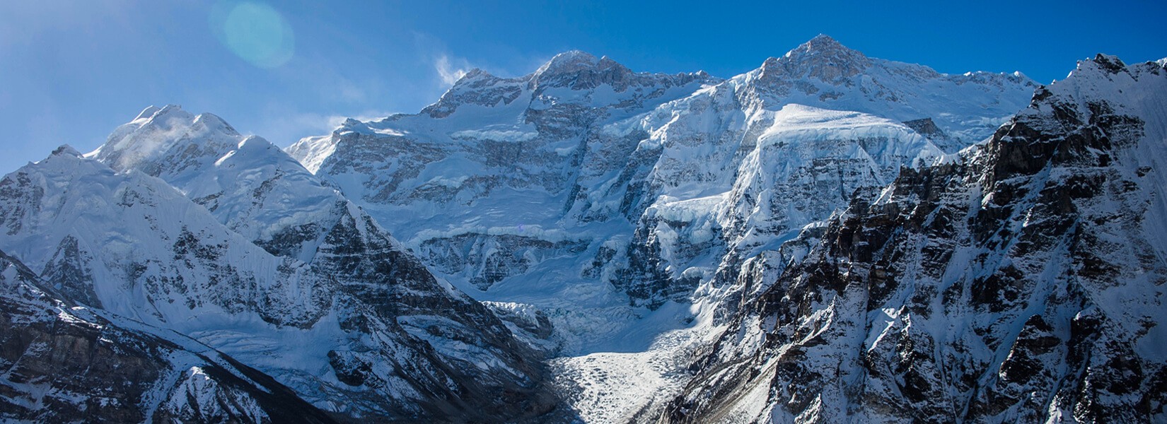
Kanchenjunga is the 3rd world highest mountain in the world. The might stands tall at the elevation of 8586m above sea level. The mountain stands tall between Nepal and India. In the Nepal part, Kanchenjunga lies in the Taplejung district of eastern Nepal. The Kanchenjunga Base Camp Trek route is not explored often like Everest Base Camp Trek or Annapurna Base Camp trek. The trail offers peaceful natural beauty with unscathed culture and tradition. If you are planning to trek in Nepal, it is one of the best treks in Nepal. Throughout the Kanchenjunga trek, they have their own culture and tradition to live on. This region is mainly inhabitant by the Rai, Gurung, and Limbu ethnic groups of Nepal. Hence, one can observe they're of kind culture, rituals, traditions, and lifestyle. 

Moreover as mentioned earlier Kanchenjunga trek is not opted for by most trekkers. Hence if you want to take the pleasure of trekking in the rural area of Nepal through the beaten path of Nepal then the Kanchenjunga region is the best trekking destination in Nepal for trekking. The trail is not only remote but is a gorgeous area in Nepal. So, if you are interested in a trek in this region then you are required to have another member as well as a local guide. 

The region not only offers views of gigantic mountains and genuine culture but also diverse flora and fauna residing in the Kanchenjunga conservation area. The conservation area houses rare and endangered animals like red pandas, snow leopards, Musk deer, Pheasants, Shy Dragon, red-billed blue magpies, and many more. To keep good memories in your life being with Himalayan Ecological Trekking will make your dream successful.   

Itinerary

Expand all +Collapse all -

Day 1: Pick up from airport transfer to the Hotel

Welcome to Tribhuvan International Airport! Our representative will meet you and transfer you to your hotel. Upon arrival, the representative will provide you with a brief overview of your program schedule.
After the initial transfer and information session, the rest of the day is yours to spend at your leisure. You can enjoy the day relaxing at the hotel or exploring the local area on your own.

Overnight stay at the hotel.

  • Accommodation3 Star category Hotel
  • Mealsup to your
  • PlaceKathmandu
  • Max. Altitude1375 m

Today, you will start your day with a visit to the ancient Swayambhunath Stupa, also known as the "Monkey Temple". This iconic Buddhist stupa sits atop a hill overlooking the Kathmandu Valley. Admire the all-seeing Buddha eyes painted on the stupa and explore the surrounding temples and shrines.

In the afternoon, visit the Kathmandu Durbar Square, a complex of palaces, temples, and courtyards that showcases Newari architecture. Wander through the palace buildings, observe skilled artisans at work, and visit the historic Kumari Temple, home to the living goddess.

After that, you will have lunch. Once you've finished your lunch, head to the Pashupatinath Temple. Pashupatinath is one of the most sacred Hindu temples in Nepal and a major pilgrimage destination for devotees of Lord Shiva. Located on the banks of the Bagmati River, the temple complex dates back to the 5th century and is a UNESCO World Heritage site.

Continue your journey to the Boudhanath Stupa, one of the largest Buddhist stupas in the world and a UNESCO World Heritage site. Walk the circular path around the stupa, observing the Tibetan Buddhist pilgrims and exploring the surrounding monasteries and shops. In the evening, return to your hotel.   

  • Accommodation3 Star category Hotel
  • Mealsup to your
  • PlaceKathmandu
  • Max. Altitude1375 m

After finishing packing our backpacks by 7 am, we will drive to Kathmandu's domestic airport. After completing the necessary procedures, we will wait for our flight to Bhadrapur, which takes approximately 45 to 50 minutes. Upon landing in Bhadrapur, our jeep will be ready to take us to Taplejung. The drive from Bhadrapur to Taplejung is about 7.5 to 8 hours, covering a distance of 242 kilometers (150 miles) via the Mechi Highway. Along the way, we will cross the Mahendra Highway. We will stop for lunch and tea breaks during the journey. The drive offers some of the best landscapes, including Harkate Bazar and Kanyan, known for its tea farms and sunrise viewpoints. This area also features good hotels and resorts for tourists. Continuing our drive, we will pass through Fikkal Bazar, a gateway to Darjeeling in India, which is just a two-hour drive away. Our journey will then take us through Phidim and Kabeli Bazar before finally reaching Taplejung, where we will stay overnight at a hotel.

  • AccommodationTea house
  • MealsMenu
  • PlaceTaplejung
  • Max. Altitude1820 m

The journey begins with an off-road drive from your starting point to Lelep, which takes approximately 6 to 7 hours. This drive follows the old trekking trail, offering a rugged and adventurous route through stunning landscapes. Leaving early in the morning, you'll head towards Mitlung, passing through a series of scenic villages and lush greenery. The trail provides a glimpse into the local way of life, with terraced fields and traditional houses dotting the landscape. As you continue, the drive takes you through Chhiruwa, a small settlement known for its charming surroundings and warm hospitality. Here, you might take a brief break to stretch your legs and enjoy the serene atmosphere before resuming your journey. The road becomes more challenging as you approach Lelep, with steeper sections and winding paths. The bumpy ride is rewarded with breathtaking views of the surrounding hills and valleys. Lelep, perched at a higher altitude, serves as a gateway to the Kanchenjunga region. Upon reaching Lelep, you'll start your trek towards Sekhathum. The trail descends gradually, winding through dense forests and along the banks of the Tamor River. The sound of rushing water accompanies you, creating a tranquil ambiance. As you trek, you'll cross several suspension bridges, adding an element of adventure to your journey. The path is well-trodden, with occasional steep ascents to be Sekhathum. Overnight at Sekhathum tea house.

  • AccommodationTea House
  • Mealsmenu
  • PlaceSekhathum
  • Max. Altitude1600 m

Starting your day early in Sekhathum, you'll start on a journey that takes you deeper into the rugged and beautiful landscapes of the Kanchenjunga region. The trail initially follows the Ghunsa Khola, a picturesque river that will be your companion for much of the day. As you leave Sekhathum, the path winds through a series of small settlements and terraced fields. You'll encounter locals going about their daily lives, adding a touch of cultural immersion to your trek. The trail here is relatively gentle, allowing you to ease into the day's hike. The route gradually ascends, and you'll begin to notice the lush vegetation giving way to more forested areas. Rhododendron, bamboo, and various other flora create a vibrant and refreshing atmosphere. Depending on the season, you might see a variety of birds and small wildlife, adding to the natural beauty of your surroundings. After a few hours of trekking, you'll reach a point where the trail becomes steeper and more challenging. This section requires careful footing as you navigate through rocky terrain and narrow paths. The climb can be strenuous, but the effort is well worth it as you gain altitude and are rewarded with stunning views of the surrounding mountains and valleys. As you continue, you'll come across several waterfalls cascading down the cliffs, providing perfect spots to take a short break and enjoy the serene environment. The sound of the rushing water adds to the peaceful ambiance of the trek. Eventually, the trail levels out as you approach the village of Amjilosa. This small, traditional settlement offers a glimpse into the local way of life, with its stone houses and terraced fields. The welcoming villagers and the tranquil atmosphere make Amjilosa a delightful place to end the day's trek. Upon reaching Amjilosa, you can relax and take in the stunning views of the surrounding landscapes. The village is perched on a hillside, offering panoramic vistas of the mountains and valleys that stretch out before you. It's a perfect spot to rest and recharge for the next leg of your journey.

  • AccommodationTea house
  • MealsMenu
  • PlaceAmjilosa
  • Max. Altitude2395 m

After completing the morning schedule, we’ll begin our trek to Gyabla. The journey from Amlilosa to Gyabla involves a gradual ascent to an altitude of about 2,870 meters (9,416 feet). This trek typically takes around 4 to 5 hours, depending on your pace and the trail conditions. Start by heading east from Amlilosa. The path ascends gently through lush forests, with occasional glimpses of the surrounding mountains. The well-marked trail weaves through terraced fields, forested sections, and small streams. As you climb, you’ll enjoy beautiful views of the valley below and distant peaks. Upon reaching the top, we’ll descend towards the river. Here, a new hotel offers a chance for a tea break or lunch if you’re hungry. From there, we’ll continue the ascent, which is steady but not overly steep. The final part of the trek leads into the village of Gyabla. You’ll notice a change in landscape as you approach, with more open spaces and traditional houses. Our tea house area is slightly isolated, with a traditional house on the left after about 10 minutes climb up. Gyabla, meaning “opposite,” is our destination for the night. We’ll stay at a guesthouse with hot lunch and dinner overnight here.

  • AccommodationTea House
  • MealsMenu
  • PlaceGyabla
  • Max. Altitude2780 m

The trek from Gyabla to Ghunsa is a delightful journey that offers both scenic beauty and cultural richness. Expect to spend around 3 to 4 hours on this segment, depending on your pace and trail conditions. Starting from Gyabla, you'll follow a well-defined trail through lush landscapes, with a gentle climb along the way. The path runs alongside the Ghunsa River, providing continuous views of its sparkling waters.

You'll soon reach Phale Gaun, a small village with a history as a Tibetan refugee settlement. Though many residents have moved on, you can still find handcrafted goods and enjoy a cup of tea or lunch in this charming spot.

After leaving Phale Gaun, you'll cross a small river and come to a junction. A path diverges toward Olangchung Gola, but you'll stay on toward Ghunsa. Keep an eye out for a memorial marking the site of a helicopter crash on September 23, 2006, to ensure you stay on the right course.

As you approach Ghunsa, you'll cross the Ghunsa Khola via a suspension bridge. This bridge offers a fantastic vantage point to take in the surrounding scenery before you continue your trek into the village. Ghunsa, one of the larger villages, has flat areas used for farming. The name "Ghunsa" in Tibetan means "winter place." The village features a police post, a primary school, and a Kanchanjunga Conservation Area project check post. overnight Ghunsa Hotel with hot dinner. 

  • AccommodationTea House
  • MealsMenu
  • PlaceGhunsa
  • Max. Altitude3427 m

Today, you're at an altitude above 3000 meters, so everyone is taking a rest day in Ghunsa. You have two options for activities: you can visit the local Gumba, or go for a day hike. For hiking, you can either take the trail to Go Lapsang-La, following the Yamatari Khola to a lake at the Yamatari Glacier, or cross the Ghunsa Khola and climb through the forest to enjoy panoramic views of the mountains and the Ghunsa valley. It's also a good opportunity to wash clothes and rest. However, I recommend doing some hiking to help your body acclimatize for the days ahead.

  • AccommodationTea House
  • MealsMenu
  • PlaceGhunsa
  • Max. Altitude3427 m

As you leave Ghunsa, the trail gradually ascends, taking you through a beautiful forest of larch and juniper. The air is crisp, and the sound of the river flowing nearby adds to the serene atmosphere. The old route has been affected by a landslide, so you will follow the new path along the south side of the river. The trail meanders through the forest, offering glimpses of the snow-capped peaks in the distance. As you continue, the forest begins to thin out, revealing more of the rugged landscape. The river remains a constant companion, its clear waters sparkling in the sunlight. You may spot various wildlife along the way, such as blue sheep or Himalayan tahr, adding a touch of excitement to the journey. Approaching Khambachen, the terrain becomes more open, and the valley widens. You'll cross the river by a suspension bridge, a thrilling experience with the water rushing below. Once across, it's a short walk to Khambachen, where you can rest and take in the stunning views of the surrounding mountains. Our night is here in the guest house with a hot dinner.

  • AccommodationTea House
  • MealsMenu
  • PlaceKambachen
  • Max. Altitude4050 m

Today, our journey will take us to Lhonak, a trek of approximately 4 to 5 hours. The landscape will transition from forests to small plants, surrounded by majestic mountains. If the weather is favorable, it promises to be a stunning day. The trail gently climbs up the north side of the river. Ensure you carry enough water or have purification tablets with you, as hydration is crucial. Along the way, there are a tea shops, known as the Four Sisters Tea Shops, located after Ramtang. You can find simple yet good food and drinks here. Beyond this point, food and drink options are available only in Lhonak. After passing Ramtang, the trail becomes more challenging as it crosses the moraine of the Kanchenjunga glacier. As we approach Lhonak, we will need to cross the Lhonak River, which has a bridge for safe passage. Lhonak itself is situated at an elevation of 4,970 meters above sea level. The village has 4 to 5 tea houses where we will spend the night. Given the high altitude, temperatures will drop significantly at night. Make sure your sleeping bag is suitable for cold conditions. If it isn't warm enough, ask the tea house owner for an extra blanket to ensure you stay comfortable throughout the night.

  • AccommodationTea House
  • Mealsmenu
  • PlaceLhonak
  • Max. Altitude4780 m

The trek from Lhonak to Pangpema typically takes 5 to 6 hours. Due to landslides that have affected the old route, the journey now requires a full day. As you start your trek, you'll be greeted with impressive mountain views right in front of you. The trail has changed, making it a more challenging route, so be cautious of falling stones, especially as you approach Pangpema. Some trekkers choose to hike from Lhonak to a viewpoint and then return, rather than going all the way to Pangpema. If you’re a climber, reaching Pangpema is a must; however, for trekkers, it’s a personal choice. Along the way, you might spot blue sheep and marmots. Pangpema, situated at 5,141 meters above sea level, offers a more demanding trek. There is a basic teahouse where you can get food and accommodation. Throughout the journey, you’ll enjoy views of the third highest mountain, which will make for a memorable experience and inspire good dreams.

  • AccommodationTea House
  • MealsMenu
  • PlacePangpema
  • Max. Altitude5143 m

Today, if you're feeling up to it, you can enjoy some time before heading to Khanbachen. The trek to Khanbachen will be familiar, as it’s the same route we took before reaching Lhonak. The path between Pangpema to Lhonak is quite up and down, which can be challenging. However, once you get past Lhonak, the trail descends and becomes easier. It will be a long day, so arriving in Khanbachen by evening and having a hot dinner will help you relax and prepare for tomorrow.

  • Accommodationtea House
  • MealsMeau
  • PlaceKambachen
  • Max. Altitude4050 m

If you’re heading to Ghunsa today, it will be a relatively easy day, and you can take your time starting. However, if you wish to visit the Janu Himal base camp, you can start with a morning hike to the Parung Fokku viewpoints, then return close to Khambachen before continuing to Ghunsa. This will take approximately 7 to 8 hours of walking in total. The landscapes and mountains are stunning if you choose to hike to Janu Himal. If you opt not to visit Janu Himal, the route to Ghunsa is straightforward. You’ll enjoy a nice dinner in Ghunsa, where you’ll find good hotels and food. The evening can be spent relaxing and enjoying your time.

  • AccommodationTea house
  • MealsMenu
  • PlaceGhunsa
  • Max. Altitude3427 m

Today, we’re heading to Selele Kharka, which involves crossing two passes that aren’t very high. The trek will take about 4 to 5 hours. As we start from Ghunsa, we’ll enter a forested area and continue along the Yamatari River, crossing a bridge. After that, the trail flattens out a bit before we begin a climb up to Tamo Top(3900m). Once at the top, you’ll find a temporary tea shop where you can get simple food and drinks if you’re hungry. From this point, you’ll have a great view of the surrounding valley, and the path becomes somewhat easier. You’ll climb again to Sele-la(4115m), from where you’ll be able to see Selele Kharka. After Tamo Top, the trail becomes rockier and more challenging. If you arrive at Selele Kharka in the afternoon, you can enjoy the clean water, pleasant sunlight, and a lighter breeze. Take this time to rest and prepare for tomorrow’s longer trek. We’ll have a hot dinner in the evening.

  • AccommodationTea House
  • MealsMenu
  • PlaceSelele kharaka
  • Max. Altitude4000 m

Today, it's best to start early in the morning, as we'll be crossing two passes and have a long day ahead. We'll need to pack a lunch since there aren't any places to eat along the way. Occasionally, we might come across a temporary tea shop as we descend. Our trek will begin with a climb, but it's not too steep. After ascending about 600 meters, we'll have a view of the top of Sinion La(4660m), where most of the climbing will occur. Beyond this point, the path becomes easier, although there will still be some uphill sections. The Mrigin(4680m) Pass after Sinion is relatively easier, and finally, Sinelapche Pass (4724m) will be the last pass of the day. From the top of Sinelapche, you'll be able to see a wide valley and even the Indian border. Take your time here to enjoy the view, take photos, and rest. The descent from here is quite steep, so everyone should be cautious to avoid knee problems. The downhill stretch will lead us to Tseram, which is the most challenging part of the walk. In the evening, we’ll reach Tseram, where there are two simple guesthouses where we can have a hot drink, local food, and accommodation. Enjoy your rest and reflect on the day's journey.

  • AccommodationTea House
  • MealsMenu
  • PlaceTseram
  • Max. Altitude3870 m

People are talking about the South Base Camp, but it’s not feasible to reach it unless you have the best glacier equipment. Without that, you can hike up to Oktang Viewpoint instead. Today’s hike doesn’t require a heavy backpack; just bring some energy bars, a packed lunch, and water. The trail begins with a gradual climb, which eventually becomes easier. This area is great for spotting blue sheep, often seen in groups. When you reach Ramche, there’s a tea shop with stunning views of the Karbu Dom Mountain. From Ramche, you'll start another climb, though it's not too steep. This will take about an hour to reach Oktang. At Oktang, you'll get a beautiful view of the south side of Kanchenjunga. After taking some time to enjoy the scenery, you'll return to Tseram by the same route. That’s your plan for today.

  • AccommodationTea House
  • MealsMenu
  • PlaceRamche
  • Max. Altitude4580 m

Today's walk is relatively easy, taking you through forests of pine, oak, and rhododendron. The journey to Torontan will take about 4 to 5 hours. We'll start by trekking downhill, following the river through one of the largest forested areas, spending most of the time surrounded by trees. It's a beautiful day where we'll be able to see snow-capped mountains. There are no tea shops or huts along the way, so it's a good idea to bring some chocolate bars for a snack. We'll arrive in Torontan in time for lunch. After lunch, you can relax and enjoy the sounds of the river and birds, making you feel as if you're deep in the jungle. In the evening, we'll have organic local food and spend the night at the guest house, which is the only one tea house in the area.

  • AccommodationTea House
  • MealsMenu
  • PlaceTorontan
  • Max. Altitude2995 m

After completing our daily morning routine, we start walking along the river. We will be following the river the entire time. After a few minutes of walking, we will need to cross a bridge. Once over the bridge, we should take the right path; the left path leads to Sherpa village or Yamphudin. This is the old classical route, which is no longer practical to complete in a single day. If we were camping, we could stay at places like Chitre or Lamite Bhanjyang, but since we are doing a tea house trek, it's better to take the right path. This route is also quite beautiful, and we will cross the river occasionally. We will be in the Red Panda zone, so if we're lucky, we might spot one. Along the way, we’ll pass the Kengsra tea house, where we can stop for tea and food. Our journey continues towards Hellok, passing through Yasang village, Sidegauda village, Mamasik village, and Lapsetar village. We’ll have the opportunity to observe the local lifestyle and agricultural practices in this area, particularly the cardamom farms. Cardamom is an herb commonly used as a spice in cooking. The trekking path is mostly downhill, but there will be some uphill sections as well, making the trek last about 7 to 8 hours. In the evening, we will stay at a tea house that provides food and accommodation.

  • AccommodationTea House
  • MealsMenu
  • PlaceHellok
  • Max. Altitude1580 m

Today, we will begin our journey around 7 to 8 o’clock. After driving for about 4 to 5 hours, we will arrive in Taplejung. We’ll have lunch there, and afterward, we’ll continue our drive to Ilam, where we’ll spend the night. During our stay, we can visit a tea farm, and in the evening, you can enjoy the sunset views. We’ll have dinner at the Ilam Hotel. 

  • AccommodationTea House
  • MealsMenu
  • PlaceIllam
  • Max. Altitude1600 m

Today, we’ll drive to Bhadrapur for our flight back to Kathmandu, similar to the start of our trek. Upon landing in Kathmandu, our car will be waiting to pick you up and take you to the hotel. This day will be more relaxed, and after checking in, you’ll have free time to explore in the evening. We’ll spend the night at a hotel in Kathmandu.

  • Accommodation3 Star Category Hotel
  • MealsMenu
  • PlaceKathmandu
  • Max. Altitude1375 m

    What's Included

    •  Airport pick up and drop all with tour planning
    • 3-star category hotel with BB plan in the city
    • flight as per itinerary
    • All transportation as per itinerary
    • Insurance and Equipment Nepali crew
    • Government license holder Trekking Guide and Porter (2 Trekker = I porter)
    • City Tour Guide with entrance fees and private vehicle
    • Medical Kit ( first add box)
    • All government and local taxes
    • Farewell Teahouse or home stay accommodation during the trek
    • During the trek all meals:- Breakfast, Lunch and dinner
    • All Government paperwork with KCAP and spical permit fees
    • Company Duffel bag
    • Nepali visa fee
    • International Flight
    • Personal expenses (like-: Battery charge, Chocolate candy, P.T, Wi-Fi more)
    • Rescue insurance
    • City meals ( Lunch Dinner) and extra night due to early arrival trekking, overstay compare to plan any reason.
    • Any bottle of drink and all kind of alcohol
    • Money wire charge
    • Tips for Guide, porter and driver ( all crew during the trek with driver)

    Useful Information

     1.    Where is Kanchenjunga?
    Mount Kanchenjunga originally pronounced 'Kang-chen-dzonga' gives the meaning of "Five treasure of snow" which are Kanchenjunga Main (8586 meters), Kanchenjunga West (Yalung Kang- 8505 meters), Kanchenjunga Central (8482 meters), Kanchenjunga South (8494 meters), Kangbachen (7903 meters). They lie on the eastern Himalayan range, i.e., on the border of northeast India (Sikkim) and eastern Nepal.
    2.    What is the best time for Kanchenjunga Base Camp trek?
    The best seasons to trek the Kanchenjunga Base Camp trek are autumn and spring. Because of the favorable climatic conditions, this is considered the best time to visit Kanchenjunga for trekking. The days are warmer and the nights are more enjoyable because of the clear sky and perfect weather. During this season, more clear and stunning views are possible due to the pure blue sky and excellent visibility.
    3.    How difficult is Kanchenjunga Base Camp trek?
    Kanchenjunga base Camp Trek is one of the toughest trekking destinations because of its rocky and isolated trials on high-altitude environment. Due to which a trekker is required to have good fitness level, acclimatization days and strong determination. 
    4.    Is permit required for Kanchenjunga Base Camp trek?
    A special permit is required to travel to the Kanchenjunga Base Camp trials. Most trekkers become disoriented and suffer from altitude sickness due to the trekking region's remote location in Nepal. To avoid these situations, the Nepalese government has made a guide and special permit mandatory in this region in a group of at least three people including guide.
    5.    What are the required permits for Kanchenjunga Base Camp trek?
    Mostly the permits are managed by a Nepal government registered trekking company. The permit fees will vary depending on the season. For more information, a trek through the Kanchenjunga region requires two permits. 
    •    Special Restricted Area Permit for Kanchenjunga (Kanchenjunga RAP Permit)
    •    Kanchenjunga Conservation Area Project Entry Permit (KCAP)

    6.    What is Kanchenjunga Base Camp trek permit cost?
    The trekking permits fees are organized by Trekking Agencies’ Association of Nepal (TAAN) and varies according to seasons. Please click the link below for more information.
    Trekking permit fees
    7.    Kanchenjunga Base Camp Trek without guide!
    As Kanchenjunga region lies in remote region of Nepal, the trekking trials are tough and labyrinth, and mostly trekkers get lost and will suffer from altitude sickness. Due to which a special permit with a license guide is mandatory in this region as stated by Nepal Government so there are no any chances for a solo trekker.
    8.    Is travel insurance required during the trek?
    Yes, travel insurance is must for those who are willing to trek in the remote region of Nepal. It is for trekkers safety and security, which will be used in exceptional emergency cases. The insurance should cover medical for emergency cases and helicopter evacuation. 
    9.    How high is Kanchenjunga Base Camp Trek?
    Crossing the off beaten trial, exploring culture and lifestyle of various ethnic group, and passing the rhododendron woods the trekker will reach Kanchenjunga Base Camp, which has an altitude of 5143 meter above the sea level. 
    10.    Foods and accommodation in Kanchenjunga Base Camp!
    Common food such as soups, bread items, egg items, pasta, potato items and a regular Nepalis dish daal-Bhat are available during the journey. For accommodation, good care will be given in the tea houses with Simple bathroom, warm and flexible sleeping beds for rest and facility for hot shower.