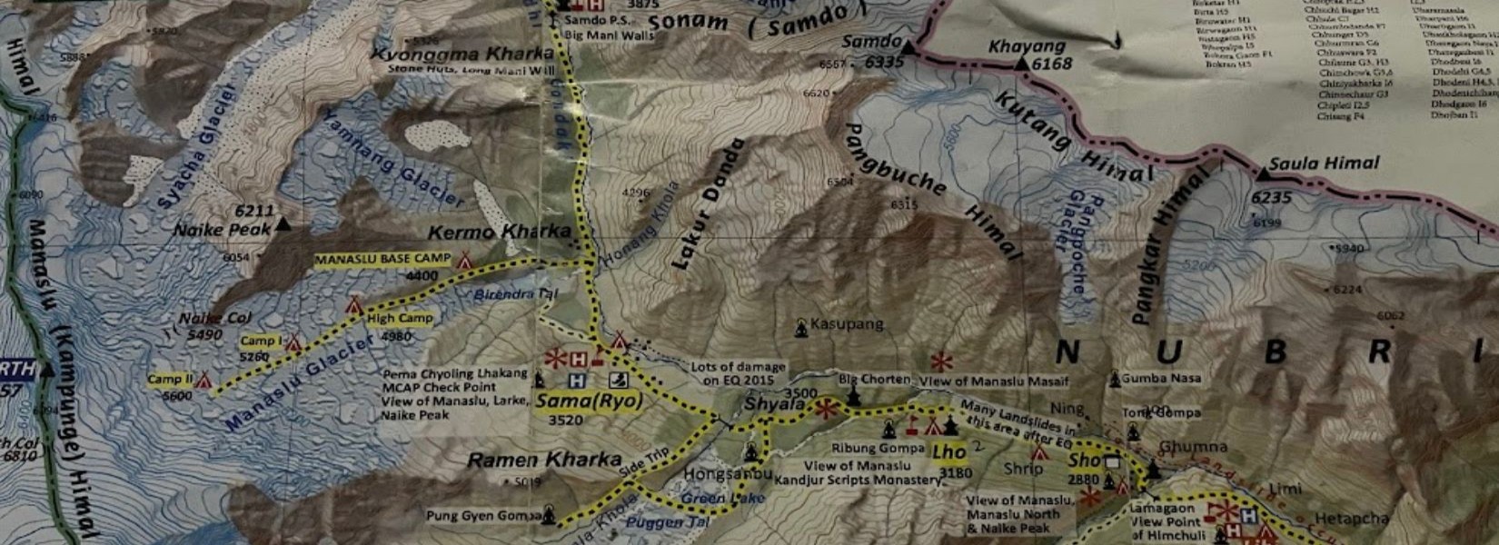
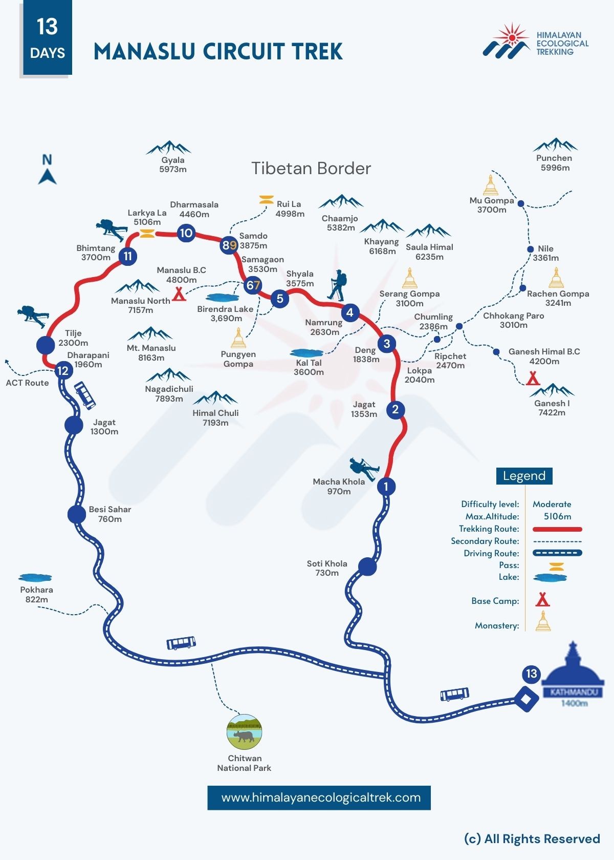
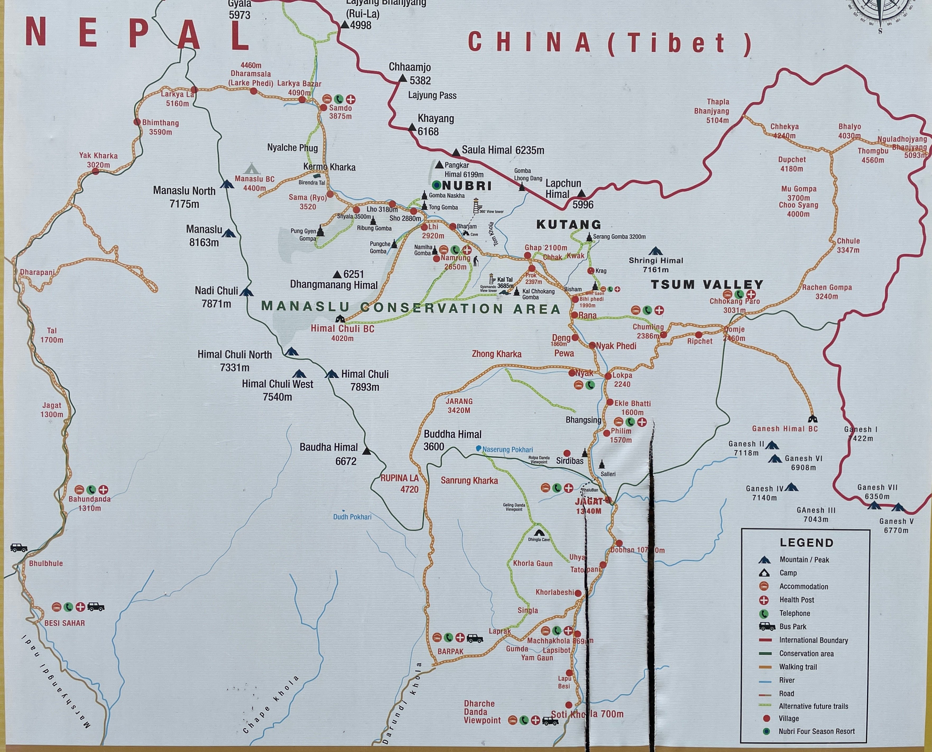
Manaslu Circuit Trek Map from Start to End of Your Journey
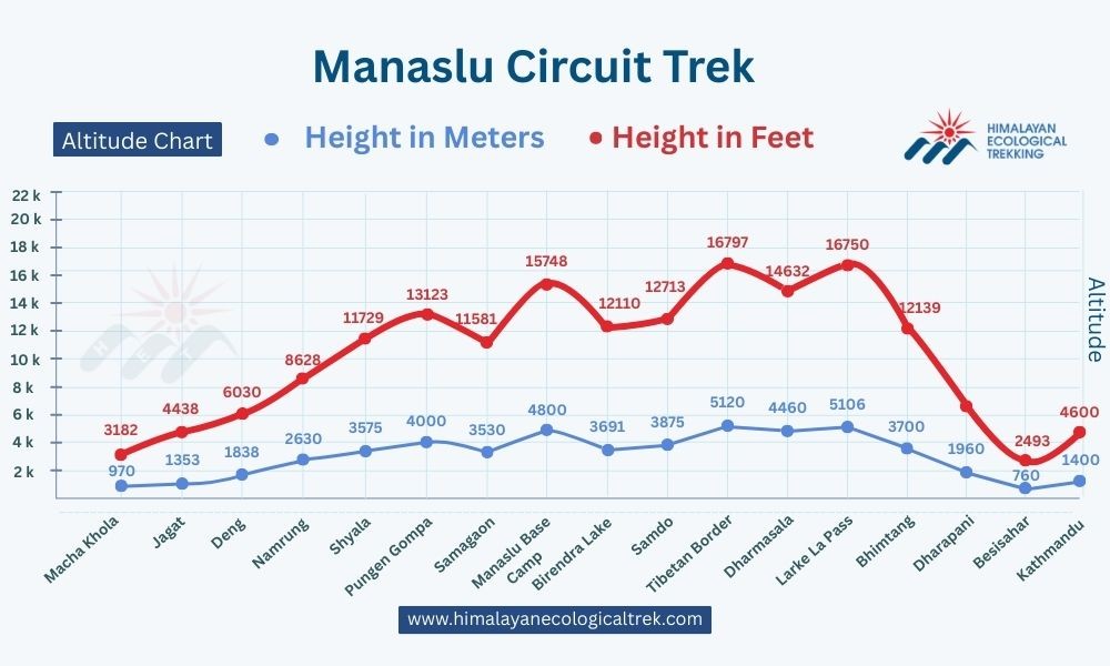
Manaslu Circuit Trek Altitude Profile
Kathmandu to Machha Khola: Start of the Adventure
Your Manaslu circuit trek route map begins with a scenic drive from Kathmandu to Machha Khola. This 8-10 hour journey takes you through winding mountain roads to the starting point of your trek at 930 meters elevation, as shown on every detailed Manaslu Circuit trek map.
The route goes through Gorkha, the historical birthplace of modern Nepal's founder. You'll see terraced fields, traditional villages, and your first glimpses of the Himalayan foothills. Machha Khola sits along the Budhi Gandaki River, where you'll spend your first night before starting the actual around Manaslu trek. Consult your Manaslu circuit map distance calculations to understand the journey ahead.
Machha Khola to Jagat: Into the Budhi Gandaki Gorge
Day one of the trek takes you from Machha Khola (930m) to Jagat (1,340m). This 6-7 hour trek follows the Budhi Gandaki River through dramatic gorges and suspension bridges, clearly marked on your Manaslu Circuit trek map.
The map of Manaslu circuit trek shows several villages along this stretch - Khorlabesi, Tatopani, and Dobhan. You will cross several suspension bridges and walk through subtropical forests. The trail can be challenging with some steep sections, but the riverside scenery keeps you motivated. Your Manaslu route map will guide you through each village and river crossing.
Jagat to Deng: Scenic Trails and Cultural Encounters
Your second day covers the distance from Jagat to Deng (1,860m) in about 6-7 hours, following the Manaslu circuit map distance markings. The around Manaslu trek map reveals this section as culturally rich, where you start seeing Tibetan influence in architecture and lifestyle.
You'll pass through Philim village, where some trekkers take a detour to Tsum Valley according to the Manaslu and Tsum valley route map. The main Manaslu Circuit trek map continues through Ekle Bhatti and follows stone-paved paths. You'll notice the landscape changing from subtropical to temperate forests with rhododendron and pine trees, all detailed in your Manaslu route map.
Deng to Namrung: Gateway to the Upper Manaslu
The trek from Deng to Namrung (2,630m) takes 6-7 hours and marks your entry into the upper Manaslu region. This section of the Manaslu circuit elevation map shows significant altitude gain, so you'll start feeling the effects of thinner air when following your Manaslu Circuit trek map.
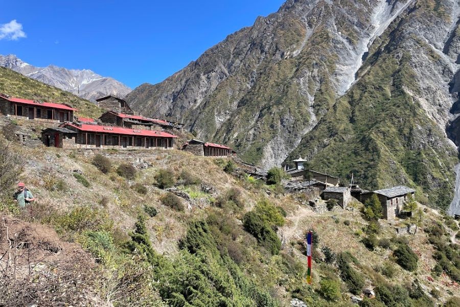
Namrung offers your first clear views of Manaslu (8,163m), Himalchuli, and Ngadi Chuli peaks, exactly as depicted on the map of Manaslu circuit trek. The village has traditional stone houses with flat roofs, prayer flags, and mani walls. You'll cross several streams and walk through forests of juniper and birch trees, with each landmark clearly marked on your Manaslu route map.
Namrung to Shyala: Glimpse of Himalayan Giants
Your journey continues from Namrung to Shyala (3,520m) over 4-5 hours, as indicated on your Manaslu circuit map distance calculations. The around Manaslu trek map shows this section is shorter, allowing time for acclimatization and enjoying mountain views.
Shyala (also called Syala) sits in a wide valley surrounded by towering peaks, perfectly positioned on the Manaslu Circuit trek map. You can take side trips to Pungyen Gompa monastery or explore the village's traditional Tibetan culture. The altitude starts affecting most trekkers here, so you'll walk slowly and drink plenty of water while consulting your Manaslu route map for guidance.
Shyala to Samagaon: Acclimatization Stop and Side Hikes
The Manaslu circuit trek route map shows that the trek from Shyala to Samagaon (3,530m) takes about 4-5 hours. Samagaon serves as your main acclimatization stop, where you'll spend two nights to adjust to the altitude, as recommended by every detailed map of Manaslu circuit trek.
This ancient trading village offers spectacular views of Manaslu's north face, clearly visible from the position marked on your Manaslu Circuit trek map. You can take acclimatization hikes to Manaslu Base Camp, Birendra Lake, or explore the village's traditional lifestyle. The Manaslu and Tsum valley route map shows Samagaon as a junction point for various side trips, making it essential to study your around Manaslu trek map before exploring.
Samagaon to Samdo: Tibetan Influence and Border Proximity
Your journey from Samagaon to Samdo (3,860m) takes approximately 4-5 hours. The landscape becomes more barren and desert-like as you approach the Tibetan border region.
Samdo is the last permanent settlement before Larkya La Pass. The village shows strong Tibetan influence with traditional houses, yak corrals, and prayer flags fluttering in the wind. You can take a side trip to the Tibet border for stunning mountain views.
Manaslu Base Camp Extension
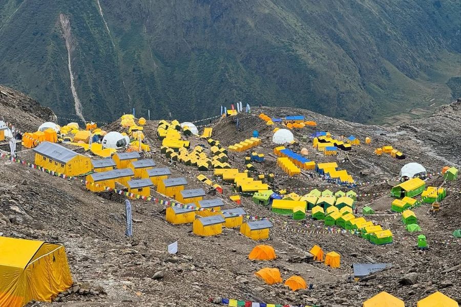
From Samagaon, you can extend your trek to Manaslu Base Camp (4,800m) with a full-day side trip. This challenging hike offers close-up views of the world's eighth-highest mountain and follows the same route used by climbing expeditions. There are two different routes to the base camp - one via Birendra Lake, and another direct route from Samagaon. The 8-10 kilometer round trip gains over 1,200 meters elevation through rocky glacier terrain. Most trekkers use their acclimatization day in Samagaon for this extension.
Samdo to Dharmashala: Prepping for Larkya La
The trek from Samdo to Dharmashala (4,460m) takes 4-5 hours and prepares you for the big day ahead, as shown on your Manaslu circuit elevation map. Dharmashala is also called Larkya Phedi, meaning "base of Larkya."
This high-altitude camp sits in a rocky valley with basic tea house accommodation. The Larkya La pass map shows Dharmashala as the last stop before crossing the challenging high pass. You'll go to bed early to start the pass crossing before dawn, following the detailed route on your Manaslu Circuit trek map.
Dharmashala to Bimthang via Larkya La Pass (5,160m): The Highlight
This day, which is marked as the climax on every Manaslu Circuit trek map, is the most difficult and rewarding of your journey. You'll start before dawn to cross Larkya La Pass (5,160m) and descend to Bimthang (3,720m) over 8-10 hours.
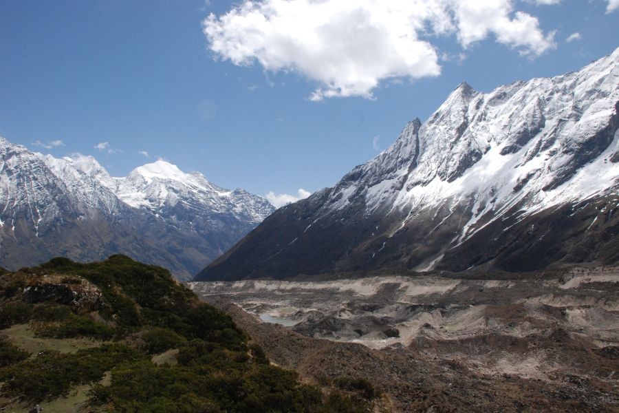
The Larkya La pass map shows a steep ascent through rocky terrain and possible snow, even in good weather. From the pass, you'll see breathtaking views of Himlung Himal, Cheo Himal, Kang Guru, and Annapurna II, exactly as depicted on your around Manaslu trek map. The descent to Bimthang is long but manageable, with stunning mountain panoramas throughout, all following the precise route on your Manaslu route map.
Bimthang to Dharapani: Descending into the Annapurna Region
Your final trekking day takes you from Bimthang to Dharapani (1,860m) over 6-7 hours, completing the circuit shown on your Manaslu Circuit trek map. The Manaslu and Annapurna circuit route map shows this section connecting to the famous Annapurna Circuit.
You'll descend through rhododendron forests, cross several streams, and pass through Tilije village, all marked on your map of Manaslu circuit trek. Dharapani marks the end of your Manaslu Circuit adventure and the beginning of the Annapurna region, where you can continue trekking or take transport back to Kathmandu, having successfully completed the entire around Manaslu trek.
Interactive Manaslu Circuit Map: Key Stops & Elevation Profile
The complete Manaslu circuit trek route map covers approximately 177 kilometers over 14-18 days. Here's the elevation profile of key stops shown on every detailed Manaslu Circuit trek map:
- Machha Khola: 930m - Starting point on the map of Manaslu circuit trek
- Jagat: 1,340m - First major village marked on your Manaslu route map
- Deng: 1,860m - Cultural transition zone on the around Manaslu trek map
- Namrung: 2,630m - Gateway to upper region shown on Manaslu circuit elevation map
- Shyala: 3,520m - Acclimatization village on the Manaslu circuit map distance chart
- Samagaon: 3,530m - Main rest stop highlighted on Larkya La pass map
- Samdo: 3,860m - Last permanent settlement on Manaslu circuit trek route map
- Dharmashala: 4,460m - Base camp for pass crossing on every Manaslu Circuit trek map
- Larkya La Pass: 5,160m - Highest point marked prominently on all maps
- Bimthang: 3,720m - Descent camp shown on Manaslu and Annapurna circuit route map
- Dharapani: 1,860m - Circuit completion point where two route maps connect
The Manaslu circuit elevation map shows gradual altitude gain with proper acclimatization stops. You'll gain over 4,000 meters in elevation before descending back to lower altitudes, making your Manaslu Circuit trek map essential for tracking progress.
Monasteries Along or Very Near the Trekking Route
Pungyen Gompa (Shyala Monastery)
Pungyen Gompa sits near Shyala village and makes an excellent side trip from Samagaon. You can reach this monastery with a short detour from the main trail, making it perfect for acclimatization hikes.
The monastery offers panoramic mountain views and insight into local Buddhist culture. You'll see ancient wall paintings, prayer wheels, and traditional architecture. When guests arrive, the monks greet them and frequently tell them about the history of the area.
Serang Gompa (Nubri Monastery)
Serang Gompa sits above Bihi or Prok Village and requires a steep detour off the main trail. Some trekkers visit this monastery during acclimatization days, though it's optional and not directly on the main trail.
The monastery sits at high altitude with commanding views of the surrounding peaks. The steep climb rewards you with solitude and spiritual atmosphere away from the main trekking crowds.
Ribung Monastery
Ribung Monastery sits directly on the main trail in Lho Village, making it easily accessible to all trekkers. This prominent and photogenic monastery represents one of the trek's cultural highlights.
You'll see traditional Tibetan architecture, colorful prayer flags, and active monastic life. The monastery's location offers excellent mountain views and photo opportunities with Manaslu in the background.
Longdan Gompa
Longdan Gompa sits near Lihi or Sho village, close enough to the trail for easy visits. This small, less touristy monastery offers authentic cultural experiences away from larger, more visited sites.
The monastery maintains traditional practices and welcomes visitors interested in Buddhist culture. You'll experience peaceful meditation spaces and interact with local monks about their daily routines.
Add Annapurna Circuit Trek to Your Manaslu Circuit Trek
The Manaslu and Annapurna circuit route map shows an incredible opportunity to combine two of Nepal's most famous trekking circuits into one epic adventure. Your Manaslu Circuit trek map naturally connects to the Annapurna Circuit at Dharapani, making it seamless to extend your journey.
Perfect Connection and Route
Dharapani is the point where your Manaslu route map meets the Annapurna Circuit trail. After completing the Larkya La pass crossing, you'll continue through Chame (2,710m), Manang (3,519m), Thorong La Pass (5,416m), and Muktinath (3,710m).
Combined Trek Benefits
When you study the Manaslu and Annapurna circuit route map together, you'll discover diverse landscapes from remote wilderness on your around Manaslu trek map to well-developed Annapurna trails. The Manaslu circuit elevation map provides excellent acclimatization for Annapurna's high passes.
Planning Your Extended Adventure
Your map of Manaslu circuit trek shows 177km, while Annapurna adds another 200km for 25-30 days total. You'll need all Manaslu permits plus Annapurna Conservation Area Permit ($30). The Manaslu circuit map distance calculations help plan this ultimate Himalayan adventure combining two world-class circuits.
This combined Manaslu circuit trek route map and Annapurna route creates one of the most comprehensive trekking experiences in the Himalayas, offering maximum value and diverse cultural experiences in one epic journey
Extend Your Trek to Tsum Valley
The Manaslu and Tsum valley route map shows exciting possibilities for extending your adventure. Tsum Valley, known as the "Hidden Valley," branches off from the main Manaslu Circuit trek map at Chumling or Philim, as clearly marked on detailed maps.
Sacred Monasteries in Tsum Valley
Mu Gompa Located at the far end of Tsum Valley, Mu Gompa requires a 4-5 day side trip from the Manaslu Circuit trail starting near Lokpa. This ancient monastery offers very scenic, spiritual, and remote experiences in one of Tibet's most untouched regions. You'll find incredible mountain views and deep Buddhist traditions preserved for centuries.
Rachen Gompa, located near the Nile in Tsum Valley, is part of the same side trip as Mu Gompa. This active nunnery holds deep spiritual significance and showcases the living Buddhist culture of the region. You can witness daily prayers and interact with the nuns who maintain centuries-old traditions.
Gongye Monastery Also located in Tsum Valley, Gongye Monastery receives fewer visitors but can be included in the same detour route. This monastery perfectly reflects the untouched Tibetan Buddhist culture that makes Tsum Valley Trek so special. You'll experience authentic monastic life away from tourist crowds.
Tsum Valley Trek Benefits
This sacred valley offers:
- Ancient monasteries and Buddhist culture (marked on specialized Tsum valley maps)
- Tibetan-influenced villages shown on the around Manaslu trek map extension
- Spectacular mountain views visible from points on the Manaslu route map
- Less crowded trekking experience compared to the main circuit map route
- Additional 7-10 days of trekking according to extended Manaslu circuit map distance calculations
You can combine both circuits for an epic 3-4 week adventure through some of Nepal's most remote and beautiful regions. The extended Manaslu and Tsum valley route map requires additional permits but rewards you with unparalleled cultural and natural experiences beyond the standard Manaslu Circuit trek map.
Permit and Requirements
Trekking the Manaslu Circuit requires several permits and preparations:
Required Permits:
- The Manaslu Restricted Area Permit (RAP) costs $100 for the first 7 days and $15 for each additional day.
- The Manaslu Conservation Area Permit (MCAP) costs $30 per person.
- Annapurna Conservation Area Permit (ACAP): $30 per person (Dharapani section).
Additional Requirements:
- Minimum 2 trekkers per group
- Licensed guide mandatory
- Trekking through registered agency
- Travel insurance covering high altitude rescue
- Good physical fitness level
You must arrange permits through registered trekking agencies in Kathmandu. Individual trekkers cannot obtain permits directly, making guided treks mandatory for this route.
Best Season for Successful Trek
The Manaslu circuit map shows a high-altitude route affected by seasonal weather patterns. Choose your timing carefully for the best experience:
Spring Season (March-May):
- Clear mountain views after winter storms
- Rhododendron blooms in lower elevations
- Moderate temperatures and stable weather
- Good visibility for photography
- Slightly crowded but manageable
Autumn Season (September-November):
- Crystal clear mountain views
- Stable weather conditions
- Perfect temperatures for trekking
- Dry trails and reliable tea house services
- Peak season with more trekkers
Winter Season (December-February):
- Extremely cold temperatures at high altitude
- Snow on Larkya La Pass
- Limited tea house services
- Challenging conditions but fewer crowds
- Requires extensive cold weather gear
Monsoon Season (June-August):
- Heavy rainfall and leeches in lower sections
- Cloud cover obscuring mountain views
- Risk of landslides and trail washouts
- Generally not recommended for trekking
- Some tea houses may close
Choose spring or autumn for the best combination of weather, views, and services along the route.
FAQs
How difficult is the Manaslu Circuit trek?
The Manaslu Circuit is rated as difficult due to its high elevation, remote location, and technical sections. You need good physical fitness, previous trekking experience, and proper acclimatization. The Larkya La Pass crossing requires mental preparation and suitable weather conditions.
How long does the Manaslu Circuit take?
Most trekkers finish the circuit in 14-18 days, depending on acclimatization and side trips. This includes the travel time from Kathmandu to the starting point and back.
Can I trek Manaslu Circuit independently?
No, you cannot trek independently. Government regulations require a licensed guide and a minimum of two trekkers. You must book the trek through a registered agency.
What's the highest point on the Manaslu Circuit?
Larkya La Pass, at 5,160 meters, is the highest point on the standard circuit. Some side trips to Manaslu Base Camp reach higher elevations.
How much does the Manaslu Circuit cost?
Costs vary based on group size, services, and season. Budget 15-25 days total including permits ($160-200), guides, porters, accommodation, meals, and transport. Expect $1,200-2,500 per person for organized treks.
Is the Manaslu Circuit crowded?
The Manaslu Circuit sees fewer trekkers than popular routes like Everest Base Camp or Annapurna Circuit. You'll encounter other groups but enjoy more solitude than mainstream trekking routes.
Conclusion
The Manaslu Circuit trek map reveals one of Nepal's most spectacular and challenging trekking adventures. This comprehensive Manaslu route map takes you around the world's eighth-highest mountain through remote villages, ancient monasteries, and breathtaking high-altitude landscapes.
Your journey from Machha Khola to Dharapani covers diverse terrain, rich cultural experiences, and the thrilling Larkya La Pass crossing, all detailed in your essential map of Manaslu circuit trek. The detailed Manaslu circuit trek route map shows proper acclimatization stops, cultural highlights, and logistical considerations for a successful adventure.
Whether you choose the standard circuit following the basic Manaslu Circuit trek map or extend into Tsum Valley using the combined Manaslu and Tsum valley route map, proper planning with accurate maps ensures safe and memorable experiences. The comprehensive around Manaslu trek map demonstrates why this trek ranks among the world's great high-altitude adventures - combining physical challenge with cultural immersion in one of Nepal's most pristine regions.
Your Manaslu circuit elevation map guides you through dramatic altitude changes, while the Manaslu circuit map distance calculations help you plan daily stages. The detailed Larkya La pass map ensures safe passage through the trek's most challenging section.
Start planning your Manaslu Circuit adventure today using our complete Manaslu route map guide. With proper preparation, physical fitness, and respect for local culture and environment, you'll create memories lasting a lifetime in this magnificent corner of the Himalayas. Remember to carry your detailed Manaslu Circuit trek map throughout the journey for safe navigation and successful completion of this incredible around Manaslu trek.
Ready to conquer the legendary Manaslu Circuit?
Don't let this incredible journey remain just a dream. Get all the details you need to make it happen:
➤ Inquire Now: Email [email protected] for full itineraries, pricing, and answers to all your questions.
➤ Chat Instantly: Message Bikesh directly on WhatsApp: +977 9851006023 for a personalized online briefing or quick chat.
Take the first step toward one of Nepal's most spectacular treks. Your Himalayan adventure is just one message away!